Wednesday, August 26, 2009
The Shortcut
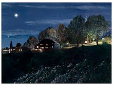
Last night I looked at the edge in the dark; today I looked at it in the day. The question is which way I can remember it best. When it's dark, the edge is clearly delineated from the space beyond it. The edge is illuminated; the space is not. But in the daytime, I can see more about what's going on with the edge as it curves around the hillside than I can at night. For instance, roughly six feet to the southwest of the Sentinel, there's a stretch of bare earth going down from the edge to the trail below. This stretch of bare earth is an unofficial trail, formed by the clambering feet of all the people who have chosen to take a shortcut from the park to the official trail, instead of walking to the end of the park, where the rock marks the official beginning of the trail. I remember at least once or twice taking photos of someone scrambling up this unofficial trail--or tearing down it. There are two large exposed tree roots that form "stairs" on this shortcut, as well as a third that sticks out at a funny angle at the bottom. At night you don't see the shortcut at all, but it's an important marker of distance in the curve as it wraps around the hill. One more thing I should mention: the greatest degree of curvature occurs on the other side of the Sentinel, in the direction of the adjacent street. I've taken a lot of photos to document this. It's a simple, humble curve--like a simple, humble song.
Subscribe to:
Post Comments (Atom)
No comments:
Post a Comment